Category 5-Hurricane Melissa Makes Landfall in Jamaica
Hurricane Melissa made landfall in western Jamaica Tuesday afternoon as an extremely dangerous Category 5 hurricane, unleashing catastrophic winds, life-threatening storm surge and torrential rainfall across the island.
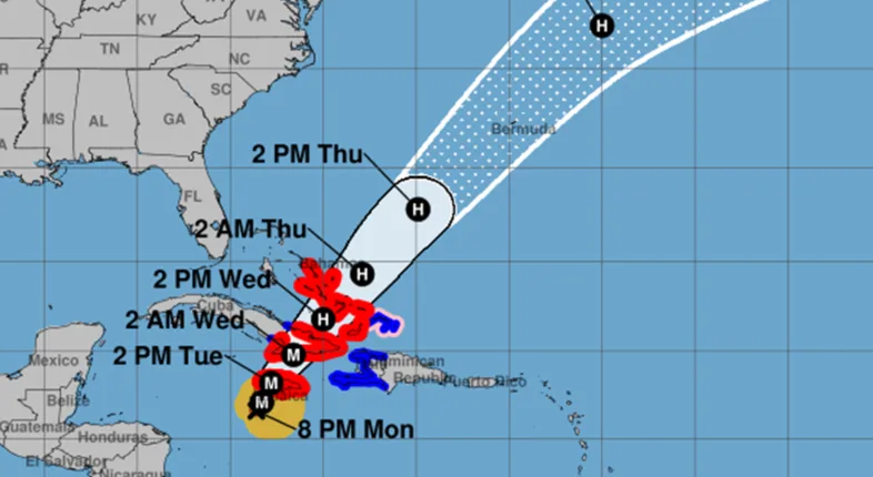
As of 2 p.m. EDT, the eye of the storm was located just 20 miles south-southwest of Montego Bay, packing maximum sustained winds of 165 miles per hour. The storm’s central pressure has reached 899 millibars — a mark of its extraordinary intensity.
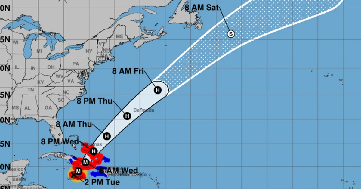
The hurricane is moving toward the north-northeast at eight miles per hour, with the core expected to cross western Jamaica over the next few hours before emerging into the Caribbean Sea and continuing on a path toward southeastern Cuba and the Bahamas.
Widespread Destruction Across Jamaica
Authorities warned residents to remain sheltered as the eyewall — the most dangerous part of the storm — continues its slow and devastating passage. Hurricane-force winds extend 30 miles from the center, with tropical-storm-force winds stretching nearly 200 miles. The country is already experiencing catastrophic wind damage and flash flooding, with numerous reports of structural failure in areas exposed to the full force of the storm.
Meteorologists have warned that wind speeds could be up to 30 percent stronger at higher elevations, posing an even greater threat to communities in hilly and mountainous regions. The National Hurricane Center cautioned residents not to venture outside during the eye’s calm period, as winds will rapidly intensify on the backside of the storm.
“Hurricane Melissa is a powerful Category 5 storm posing a serious threat to the lives and livelihoods of Jamaicans. In its aftermath, recovery will take every helping hand. Together, let us stand ready to protect and help families recover, rebuild homes and restore livelihoods once the storm passes,” Jamaica Prime Minister Andrew Holness said Tuesday.
Life-Threatening Rainfall and Flooding Threat
Melissa is expected to dump between 15 and 30 inches of rain across Jamaica, with some areas potentially reaching 40 inches. The risk of catastrophic flash flooding and widespread landslides is high, particularly in southern and western parishes.
Rainfall totals of 10 to 20 inches are forecast for eastern Cuba as the storm approaches the island tonight. In the Southeast Bahamas, 5 to 10 inches of rain are expected, with tropical storm conditions beginning later today and hurricane conditions arriving on Wednesday.
Watches and Warnings Across the Region
Hurricane Warnings remain in effect for Jamaica, southeastern and central Cuba, and the southeastern and central Bahamas. Tropical Storm Warnings extend to Haiti, the Cuban province of Camaguey and the Turks and Caicos Islands.
Melissa is forecast to remain a powerful and dangerous hurricane as it approaches Cuba early Wednesday, before moving across the southeastern Bahamas later in the day. Residents in Bermuda are also being advised to monitor the storm’s progress closely, with watches possible later tonight.
A Region Braces for Impact
As Melissa carves its destructive path across the northern Caribbean, emergency crews and national agencies are on high alert. The storm marks one of the most powerful hurricanes ever to directly strike Jamaica, and officials warn that the coming hours will be critical.
For official storm information, residents are urged to follow updates from national meteorological services and the National Hurricane Center.