
By Steven Keats
CJ Contributor
Being in the shipping business and always curious about exploration, I developed a collection of rare maps that focused on the Americas. Several years ago part of the collection was presented at the University of Florida School Of Latin American Studies and this is how they described the exhibit:
“These maps represent the Age of Exploration, a period marked by navigational discoveries and cultural exchanges that forever changed the lives of Caribbean and Latin American peoples. Each serves as an example of the historical evolution of cartography, and as a symbol of the social changes fostered during the 16th and 17th centuries. Although enterprises such as slavery and colonialism also rose during this period, the newfound eagerness to explore the world did lead to scientific breakthroughs, eloquent systems of trade, multiculturalism, and events that make up a large part of our collective history.”
Many of the Age of Exploration maps are unique; found only in the major national libraries in Europe and the United States. But there are many affordable examples to build your own collection or to display at home or office depending on your interest. Facsimiles are also available from many specialized shops.
Today you can punch in your desired GPS coordinates in a computer and be off to your destination. Not so centuries ago when maps were made on manuscripts or vellum or later, printed on paper from block prints or copper engravings. Maps were used not only for navigation but were used in business and to impress friends and associates.
Now you will learn a little about how the brave explorers from the 15th and 16th centuries surmised what the world looked like and how the science and business of cartography developed. We will explore some of the foundation maps and hear some interesting stories particularly about the Caribbean and Americas.
One of the first things to notice is that the projections used in early mapping look nothing like the usual Mercator Projection we are accustomed today.
Our first story: Claudius Ptolemy, the head librarian at Alexandria around the Second Century AD.
The Benchmark Map of Exploration
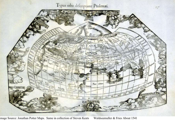
Before Columbus made his westward journey, this map generally describes the known world. The author never actually made a map. His name was Claudius Ptolemy, a librarian from Alexandria from the Second Century. What Ptolemy did was to list the coordinates of major cities and points of interest then known.
His tables were lost until the Middle Ages when they were put to the format of a map. It is a benchmark map from which the Age of Discovery would spring forth. This particular example was made by Martin Waldseemuller and Laurent Fries. Waldseemuller is particularly famous because a later map of his made in the early 1500’s first named the New World for Amerigo Vespuchi. (His other maps to follow). When Columbus sailed it was well known that the earth was round but considering from Ptolemy’s version; it drastically underestimated in the earth’s diameter. Columbus initially thought he had reached the Indies. As exploration pushed further afar, the basic design of the Ptolemaic Map continued well after Columbus’ discoveries until it lost favor to more modern plots.
Columbus Manuscript Maps
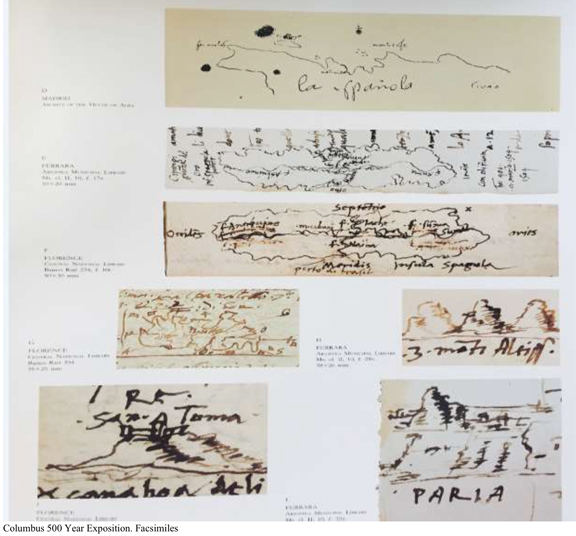
These maps made by his own hand depict his various renditions near to Navidad, Haiti (Hispaniola) which was his first site to be settled as well as other islands in the Caribbean including Trinidad and the Gulf of Paria. There are no plumb lines or grids and the inks remained very durable over the almost five centuries since they were drawn.
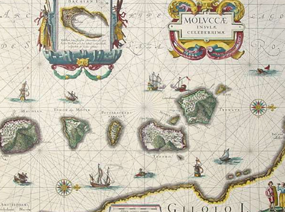
What the Fuss Was All About — The Spice Islands
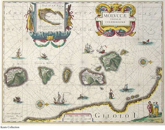
The Molucca Islands were an archipelago near to the Celebes known in the Middle Ages as the source for the wildly expensive spices of Nutmeg and Mace. The Nutmeg legacy lives on today in Grenada.
What prompted the usual European powers to fight hardened battles to control these islands? The traditional trading routes though the Silk Road and Italian middle men were closed off. A competition ensued seeking alternative sea routes, with The Dutch, Spanish and Portuguese slugging it out as they pushed further out from Europe. Initially, the push succeeded via the Horn of Africa. But it was Columbus who was searching for a route going the other direction. This copper-engraved plate map is in typical Amsterdam style made by one of the most famous Dutch era families of cartography.
Juan de Cosa Map of the America and West Indies
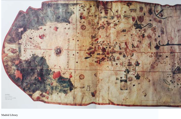
This priceless 1500 map is found in the Museum de Madrid. It depicts the first eye witness and conceptual understanding of the Caribbean and New World. The islands of Cuba, Hispaniola and Antilla (Puerto Rico) as well as the Leeward and Windward Islands are depicted.
Europe and Africa as known are on the right side. Juan was the owner of the Santa Maria and sailed as Captain with Columbus on his first voyage and as his navigator and pilot on the second and third voyages. The map is made on vellum. What is most intriguing is that on the left side over Central America, Cosa hints at; but cannot confirm that there is a way across the isthmus to reach another sea. He puts a Coat of Arms over the suspected area (roughly corresponding to just near Panama).
Waldseemuller World Map of 1507: “The Cat is Out of the Bag”
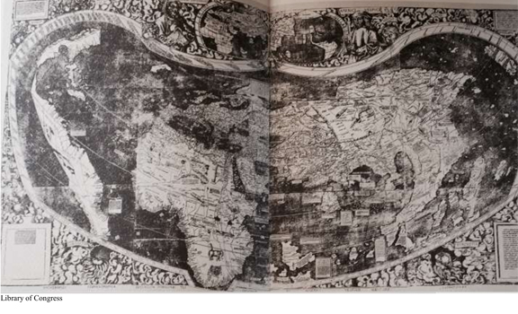
Martin Waldseemuller was a theoretical cosmographer based in St Die, France who published the first map to call the newfound world America, after Amerigo Vespucci.
There is only one copy of this wall map and it is now in the Library of Congress after having been found ensconced in a castle in Bavaria.
As you will notice, this is a Ptolemaic map, in which Africa did not exactly fit within the mold of the initial map structure.
On the left is what was surmised to be the new world but not even the Pacific Ocean was fully understood to be on the west side of South America.
Shortly afterwards, Waldseemuller had second thoughts about giving credit to Vespucci, who was known to be a self- promoter.
He did make many important discoveries, contributing to the general new found knowledge of the hemisphere; but Waldseemuller tried in later maps to go back to calling the new world, just that or Terra Incognita… but it was too late.
Waldseemuller 1513 Map – There Was No Turning Back
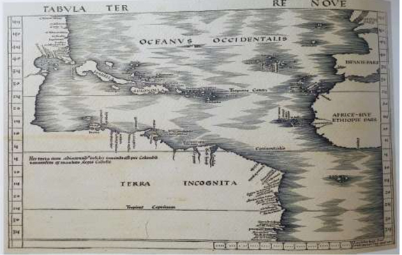
Waldseemuller tried in several subsequent maps to deflect the New World’s naming of America. In this map he removed the America label and reverted to the old term, “Terra Incognita.” But it was too late — the name America had taken hold. We were not destined to be called Columbians! Cuba, and the Greater and Lesser Antilles were by now fairly well conceptualized as well as the North Coast of South America. What was the west of the Caribbean was still not defined.
Sebastian Munster- De New Welt 1541
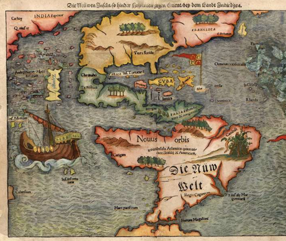
Barely 49 years after the Discovery, this map drawn by the famous Munster in his book Cosmographia was the first map to put North and South continents in their relational context. It also is a map rather available in the open market (mostly later 1560+ editions). This wood block print is one of my personal favorite because of all the things going on here.
For instance, South America is still called the New World. There is the obligatory cannibalism allegory. The flags of Spain and Portugal are delineated based on the agreement made in the Treaty of Tordesillas, whereby Spain got everything to the west of the treaty line and Portugal to the right. Brazil was gained by Portugal by a fluke as its discovery was by accident as the Portuguese explore Cabral had to tack towards the west in order to get around the horn of Africa. Zampinga is shown to be in close proximity to America. But this was Japan and it was much further. You notice that the breath of the Americas seems stretched. While explorers had a pretty good idea how to calculate latitude, it was not for several more centuries that calculation of longitude could be done accurately with the advent of the chronometer. Lastly, a tribute to Magellan’s voyage is made with the image of his flagship Victoria.
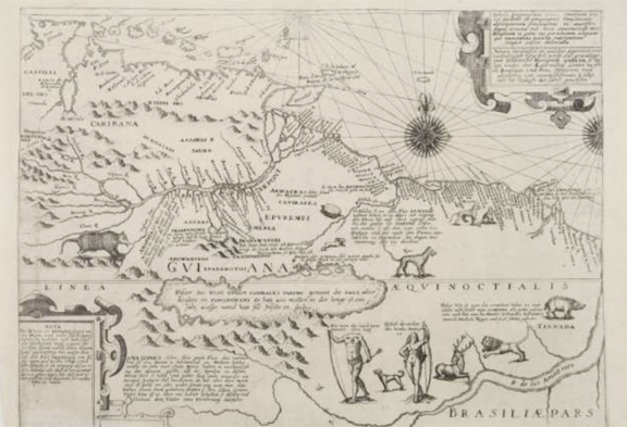
The (Futile) Quest for El Dorado- As Described by Sir Walter Raleigh
Keats Collection
In 1595, the English explorer Sir Walter Raleigh set out for the legendary king , El Dorado thought to be in the northeast of South America near the Guianas or Venezuela. Legend held that that El Dorado has gold dust blown on his body instead of bathing. This engraved map by the German, Theodore De Bry, perpetuated a myth as late as the 1800s that somewhere in these jungles was the “Golden One”. The legend goes that his servants blew gold dust on him every morning. Sir Walter made several trips to this area with stop overs in Trinidad, where he captured the Spanish Governor.
In his book, Discoverie of Guiana on which this map is based, Raleigh speaks of the Amazon woman warriors and the headless tribesmen known as the Ewaipanoma.
Today these tribesmen can be described as the Yanomani Indians who walk with their heads slouched to their chest giving the appearance of being “headless”. Sir Walter never made it back with the goods (gold) but he kept Queen Elisabeth interested enough to allow him to make other, unsuccessful forays. Eventually the gig was up for Sir Walter; after getting caught with one of the courtesans in the Queens Court, Raleigh was sent off to the Tower of London where he languished in comfort until the day his head was separated. The cartographer De Bry was responsible for writing one of the first travel logs of the voyages to the Americas and did his part to spread false propaganda about the native Indians who were shown to be brutal in their treatment of the Spanish conquistadors by the pouring of molten gold down the captured and cut up for the BBQ.
Classic West Indies Sea Chart – 1680
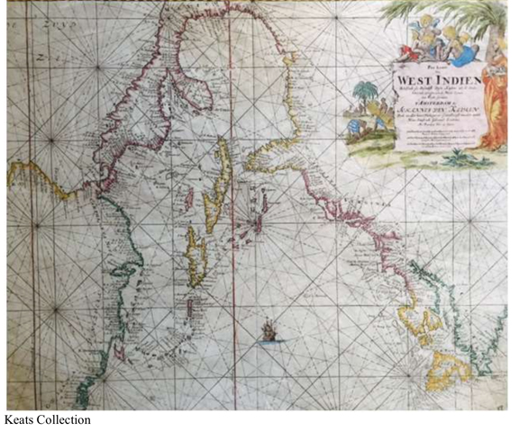
Johannes Van Kuelen was another great Amsterdam cartographer of the 17th Century who competed with the Bleau family. This map features an orientation with North being to the right. By this time the Caribbean was quite defined and relatively accurate. The lines are called plumb lines and were used for navigation plots. This is one of the most attractive maps of the Caribbean with a very beautiful cache in the upper right. Great lengths were made to gain an edge over competitors and in the case of Van Keulen, he received a patent from the State of Holland to publish his sea charts.
While my collection and interest is focused on the Americas and Caribbean; you can chose whatever region or time period that strikes your fancy. We have not scratched the surface of the tools used in navigation or many of the accidental events that shaped the outcome of the geography. Did you know that longitude could not be accurately calculated it was not until Harrison’s Type-4 Chronometer was invented in the mid-1700s? That’s almost 270 years after Columbus made his first voyage!
Hoping that your appetite has been whetted with this brief introduction, there are so many sources to find to learn more about map collecting, whatever level your interest might be.
Steven Keats is Vice President/Partner at Kestrel Liner Agencies LLP.


