Above: a map of the quake (graphic: United States Geological Survey)
By the Caribbean Journal staff
Above: a map of the quake (graphic: United States Geological Survey)
By the Caribbean Journal staff
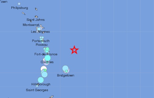
A 6.5-magnitude earthquake northeast of Barbados caused shaking across the Eastern Caribbean early Tuesday morning, according to the United States Geological Survey.
The quake, which occurred 172 kilometres northeast of Barbados, struck at around 5:27 AM local time. The University of the West Indies Seismic Research Centre also recorded the quake has having a magnitude of 6.5 on the Richter scale.
The quake was felt across the region, with weak shaking felt as far north as Philipsburg, St Maarten and light to moderate shaking from Martinique all the way down to Grenada.
The most reports of shaking were felt in Martinique, which was about 128 kilometres directly west of the quake’s epicentre, along with Barbados.
There were not any reports of damage or injuries, although authorities in Martinique were recommending “extreme caution” in coastal areas, according to reports.
Other countries that felt shaking included St Lucia, Dominica, St Vincent and the Grenadines, Guadeloupe, Trinidad and even Venezuela.
It was the second 6.5-magnitude earthquake in the region in just over a month, following a similarly-sized quake in near Puerto Rico in January.
It was the strongest quake in that portion of the region since 2007, when a 7.3-magnitude quake struck near Martinique. As a point of reference, the earthquake in 2010 in Haiti was a 7.0-magnitude on the Richter scale.
The 2007 Martinique quake had been the largest in the region since a 6.9-Magnitude tremblor near Antigua in 1974.